Tuesday, July 31, 2012

Wy'east: Back To The Future

Returning to the mountain of my youth, longtime friend Tom Maloney and I headed north for a wilderness experience and the opportunity to visit with family and friends. Mt. Hood’s imposing presence, particularly with a white winter cape, captivates practically everyone who comes in sight of it, and especially those who live in Portland.

Having spent most of my youth in the forests surrounding Wy’east (as it was known to the Multnomah Indians), my family’s association with the Mt. Hood actually predates my own existence. My grandmother's family had purchased a cabin in nearby Welches near the Salmon River, so my parents spent their youth "on the mountain."

In the early ‘60s, we would camp every summer on the Mt. Hood National Forest. Later, as a Boy Scout, we would “rough it” at various lakes on the mountain's flanks. As part of a climbing group, I reached the summit with my Dad at age 11. I have climbed Mt. Hood another 10 times since, most recently in 2003, when I shot a summit photo (above) of the mountain's shadow at sunrise (coincidentally, with buddy Tom Maloney). We plan to climb the mountain again.

According to local legend, Wy’east (Mt. Hood) was a rival of Klickitat (Mt. Adams) for the love of Loo-Wit (Mt. St. Helens). After a vicious battle of fire and brimstone that must have resembled the end of times to the natives, and ultimately destroyed the Bridge of the Gods over the mighty Columbia River, Klickitat emerged victorious.

The first non-native people to see the mountain were officers in the employ of Captain George Vancouver who had crossed the bar and entered the great river, sailing upriver as far as Rooster Rock. They named the mountain for Lord Samuel Hood, a British naval officer. The first Americans to see Wy'east were Lewis and Clark: “This is the Mt. Hood (of) Vancouver,” they noted in their journals.

Much like the top of the mountain when lenticular clouds circle the summit, it’s not clear who actually first scaled Mt. Hood. Joel Palmer is listed as the first to attempt the mountain in 1845, although David Douglas (the Scottish botanist of Douglas fir fame) is credited by some as having first scaled the peak in 1833. Less credible is the claim of the first successful attempt by a group that included Palmer and Thomas Dryer, founding publisher of The Oregonian, in 1854.

The Mazama Climbing Club later discredited this claim and determined that Henry L. Pittock (who succeeded Dryer as owner and publisher of The Oregonian) made the first authenticated climb. Pittock also built the 22-room renaissance revival known as the Pittock Mansion overlooking downtown Portland. His climbing party suffered from snow blindness and minor injuries and had to remain in camp for several days before returning to Portland.

Since then, of course, the mountain has been climbed in every month of the year, by youngsters who could barely toddle to three-legged dogs to septuagenarians in tennis shoes. In the early part of the 20th century, the Forest Service staffed a lookout on the summit. Weddings have been performed up there. People have died up there.

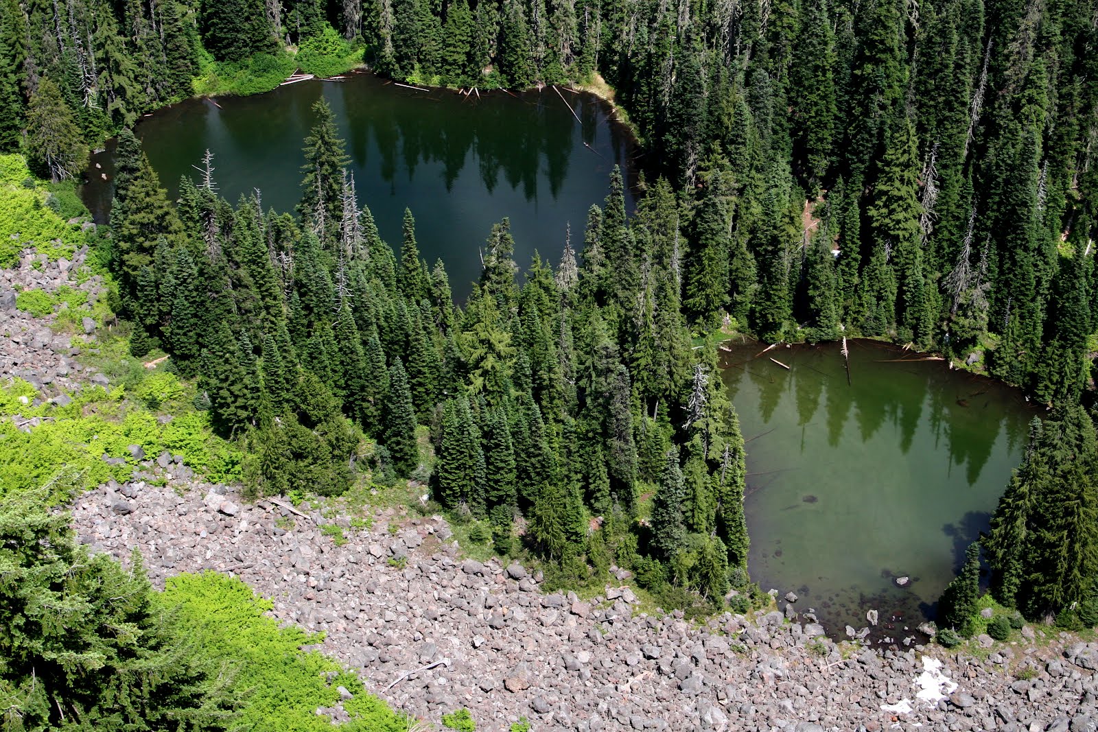
So it was with great anticipation that I returned to the mountain for a bit of scenery and socializing: a hike up to the summit of Tom Dick and Harry Mountain (above) and a trip to Timberline Lodge before hooking up with my sister Carla and husband Bob –- who own a home in Welches on the Salmon River –- for dinner at the Zigzag Inn.

After a trip into Portland to visit with Iona Maloney, the 95-year-old matriarch of the family, and longtime friend Greg Seymour, we went back up the mountain to Brightwood for a Taylor family reunion in honor of friends Pat and Sharon Taylor. All told, a great trip back to the mountain; it was all the motivation I needed to get back there in the future -- and sooner than later.

Tuesday, July 24, 2012

Lowder Mountain

In an effort to get a few conditioning hikes in before disappearing into the wilderness later this summer, frequent hiking partner and friend Steve Still and I ventured up the Lowder Mountain (above) trail in the McKenzie River Valley on Wednesday, July 15.

Starting above Cougar Reservoir at Quaking Aspen Swamp (yes, there were a few mosquitoes) the trail enters the Three Sisters Wilderness and continues for about three miles to the summit. Wildflowers –- such as the paintbrush below –- were in abundance.

The flat, open top of Lowder Mountain at first seemed like any high-elevation meadow rimmed with Pacific silver fir and mountain hemlock until we ventured to the east side of the summit for a peak at its precipitous cliffs and a view of the Three Sisters.

At the base of the cliffs at Lowder Mountain are two lakes -– Lake Karl and Lake Ruth -– that sparkled about 1,000 feet below. The six-mile hike had about a decent elevation gain (and loss) and was a perfect conditioning trip with rewarding views.

Saturday, July 7, 2012

Some, Some, Summertime

With the school year winding down and a soggy spring on the wane, it was time to think about fun, frolic, fruit and fireworks. And so it was on Saturday, June 30, Paul Turcott (aka “Raoul”) and I departed for Owl Farm on the Wenatchee River (above) near Plain, Washington.

After celebrating with the Enders family in their new home in Brownsville, we proceeded to Portland to spend the night with our old friends, the Donnerbergs, in an effort to break up the 400-mile trip.

Little more than a week after celebrating the summer solstice, the weather remained miserable –- warm, but grey and wet. La Nina still held the Willamette Valley in her clutches, so the next day, we struck out due east up the Columbia Gorge on Interstate 84 in search of the elusive solar orb. As expected, we were rewarded just east of Hood River as the sun joined us for the remainder of our trip.

Continuing on, we stopped once again at a fruit stand north of Yakima for a bag of fresh cherries. Most who have traveled north on U.S. 97 in Washington will recognize the place; you can’t miss the gigantic “FRUIT/WINE” sign with 20-foot-tall lettering.

We stopped at several makeshift fireworks stands staffed by members of the Yakama Nation, who are always delighted to chat. We asked why a few stands were located just outside the reservation boundary. We were informed that these were known as “vancouvers,” or little islands of Yakama territory separated from the main plot after some Native Americans had sold their land.

In addition to organizing the place for the summer, Raoul and I drove up the Chiwawa River to the old mining community of Trinity for a bit of reconnaissance on trails into the backcountry. Thanks to a wet spring, conditions remained difficult in the Glacier Peak Wilderness, with high water creating treacherous creek crossings (above).

The upside to a wet spring, however, is a flower festival extraordinaire, as witnessed by the "lupine-palooza" (below) on display near Owl Farm at the entry to Shugart Flats.